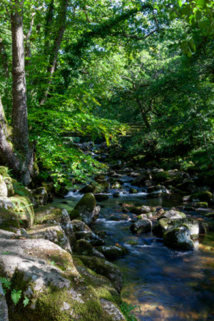
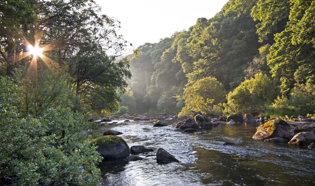
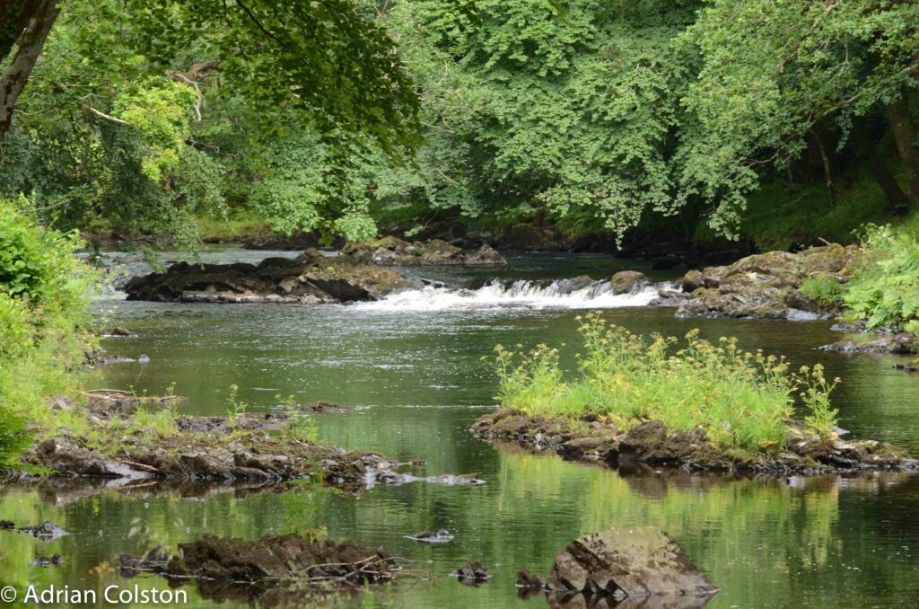
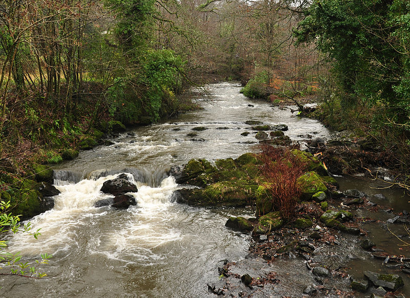
Watercourses

NOT PROOF READ YET

Devon’s network of watercourses (its rivers, streams and canals) is x,xxx kilometres long.

This network provides both wildlife habitat and critical connectivity across the county.   

Only 22% of Devon’s rivers are assessed to be in good ecological status due to pollution and physical modifications. 

Waterfall near Vennford, Annie Houston

River Yealm – National Trust Images, Paul Harris

River Teign – National Trust Images, John Miller

Snapshot

What wildlife rich looks like

Clear, unpolluted water in a channel that is diverse and complex, reflecting its geology and local conditions. The watercourse banks and surrounding land are also diverse and create a natural corridor weaving through the landscape.

Focus Species include

Freshwater mammals (otter, beaver, water vole), migratory fish (including Atlantic salmon and eels),  rare bryophytes, beetles, flies.  The riparian zone provides critical habitat and connectivity for a range of Focus Species include bats, butterflies and birds.

Status

Natural watercourses aren’t statutory irreplaceable habitats but should be considered as such.

About

A combination of high rainfall and geology means that Devon has a higher density of watercourses than most of counties. Devon’s watercourse corridors include rivers, streams, artificial canals, their vegetated banks and floodplain habitats. Together these habitats form the wildlife rich veins of Devon’s nature network providing unique habitats and critical connectivity for wildlife.  

Most natural watercourses in Devon start life as fast flowing streams (headwaters) in the bogs of Dartmoor and Exmoor or rise on the north Devon culm wetlands or the wetlands of the Blackdown Hills scarp slopes.  However there are springs and streams all across Devon which feed into the complex watercourse network.

The faster flowing upper reaches of rivers support species such as dipper, grey wagtails, salmon, bullhead and trout.  Ancient woodlands have survived along many of the steeper Devon river valleys supporting moisture loving mosses and lichens. Slower, calmer waters in the lower reaches support plants, invertebrates and birds such as heron and kingfisher.  Vegetated river banks provide connectivity for species such as bats. Each watercourse has its own assemblage of species suited to its unique character and history.

(LOTS OF DROP DOWN TEXT- UNSURE HOW TO INPUT THIS YET) – HAVE LEFT OUT FOR MEANTIME

“Freshwater habitats across the UK are under pressure. Populations of many freshwater species are declining, with over 10% threatened with extinction. An estimated 90% of wetlands, have been lost over the last century, while most rivers and lakes are not considered to be close to their natural state in any part of the UK.” Only 16% of rivers and lakes achieve Good or High ecological status in England (UK Parliament Post Note 709). 
 
The lower section of the River Axe is designated a SSSI and SAC because of its important plant communities; this is Devon’s only statutory protected river. It is classified by Natural England as being in “unfavourable condition, declining”. This is mainly due to nutrient enrichment, especially from phosphates and siltation. 
 
Across Devon there are 695 river and estuary waterbodies. The main rivers and tributaries are classified according to their ecological status by the Environment Agency under the Water Environment Regulations.  For more details see the link to River Basin Management Plans in Find our more. Of those classified in 2019:
None were at High Ecological status
22% were Good
62% were Moderate (note that Moderate is still equivalent to a “Fail”)
15% were Poor
1% were Bad.
 
The key factors affecting these assessments include pollution from rural areas, pollution from waste water and physical modifications. These are detailed further below.
 
WCRT to edit – None of Devon’s rivers are now in their natural condition as they have all been heavily affected by human activities over centuries. The degree of damage varies, but most of our rivers have lost so much of their original structure that returning them to their natural state is no longer a realistic goal. Instead, the goal should be to maximise their value for wildlife within the form they have now taken.

Key pressures and opportunities

Agriculture: The intensification of agriculture since World War 2, driven by the need to improve food security, has seen higher livestock numbers (generating more manure), more land-drainage, the widespread use of artificial fertilisers and frequent cultivation of the ground during wetter times of year; all these can trigger the runoff of top soil, fertilisers, pesticides, manure and other pollutants into rivers. Funding for land management changes that can support improvements to rivers is now available to all farmers and landowners through the Environmental Land Management Scheme. Targeting this funding to where it can have most effect is an important role for this Local Nature Recovery Strategy. Several Landscape Recovery Schemes in Devon have water quality and quantity, including river restoration, as their main or significant focus.

Human waste: Population growth and lifestyle changes mean there’s a need to treat ever-greater volumes of wastewater.  Our treatment plants – both public and private – are often not up to the task. The EA and SWW have plans in hand to tackle these problems, see links in Find out more.

Roads: Run-off from roads can contain damaging pollutants and often runs directly into watercourses. There is growing awareness of this problem and the need for additional treatment to reduce impacts.

A few rivers flowing from Dartmoor, such as the West Dart, have been identified as being in ‘acid vulnerable catchments’.  This may be due to flushes off degraded peat or possibly due to conifer plantations.  See a map in Find out more.

In some stretches of river the lack of tree management means the river has become too shaded. In others a lack of trees exposes the river to high temperatures and provides no cover for fish. In the wider watercourse corridor the loss of many habitats to agriculture and development means the river has lost essential buffering and connectivity.

Invasive species are able to spread rapidly in rivers and can damage ecosystems. Examples include Himalayan balsam, which can blanket riverbanks and shade out other species; and the American signal crayfish, which outcompetes our native white-clawed crayfish and can also destabilise riverbanks with its burrows. See Invasive species for more detail.

Flooding: Higher and more intense rainfall combined with our more intensively-managed landscape and a legacy of straightening and channelling rivers means that flooding is a growing problem. Some soils are easily compacted, so that rainfall runs off them too quickly into rivers, rather than soaking in to the ground, and this can cause flooding downstream.  Increasingly nature-based solutions such as natural flood management are being used to reduce flood risk and these interventions can often provide good habitats for wildlife.  The re-introduction of beavers is also a huge opportunity as these natural engineers create wildlife-rich wetlands that slow the flow of water in times of flood.

Abstraction: Some of Devon’s rivers are important sources of drinking water and most are also used to irrigate crops. This abstraction can reduce water levels to the point that wildlife is put at risk. Population growth and increased tourism means that urgent action is needed in some rivers. This has been recognised by government and the EA and SWW are developing plans to tackle these problems. Plans include reducing household water-use, fixing leaks in the system and, as a final resort, building new reservoirs (although none are planned in Devon) Beaver-created wetlands can also help maintain water levels.

This is causing more intensive rainfall causing flooding that erodes riverbanks more intensively. It’s also causing periods of drought and / or high temperatures that can kill many river-dependent species. An opportunity arising from this is that climate change is making people ever more aware of the impact of water on our lives and this should encourage action. Floods and droughts are more frequent and more intense and these are affecting people’s lives and business viability to a degree never seen before.

Humans have modified river channels for many reasons, often to try and reduce flood or erosion of properties, including straightening, building embankments, dredging stone and removing woody debris and bankside trees. These changes are often unsuccessful because they can cause the river to behave in a more damaging way somewhere else in the system. Weirs and other barriers have similar effects. The loss of gravels for fish spawning is a notable.

(to edit thro discussing with WCRT).

Since the Bronze Age, farming and clearance of woodlands has caused soil runoff and thick layers of sediments have accumulated the floodplain. Many rivers have since then cut a deep channel through this soft material, leaving them way below, and disconnected from, their floodplain. At times of flood they now carve even deeper in their channels, often going through the original layers of stone that “armoured” the riverbed, and into yet more soft material below. All of this adds further to the amount of sediment in the river and flowing out to sea, which damages ecosystems yet further.  (not sure we understand this – to discuss and explain)

On our now drained and cultivated non-estuarine floodplains, reconnecting floodplains as part of a natural system is  is likely to be extremely costly. In most cases a better use of resources would be to establish a wide diversity of other habitats on the floodplain as opportunities arise.    

There is a growing awareness that the state of our rivers has declined alarmingly, and action must be taken to reverse the declines. This awareness is driving legislative and policy changes and more resources are being channelled by the state and by businesses into tackling the problems. Local communities, and voters, are part of the drive for change. There is a groundswell of people coming together to put pressure on decision-makers to improve our rivers. Many are launching public campaigns and many are training as citizen scientists to monitor water quality and river ecology. Partly as a result there is a growing awareness of, and technical skills base in, working with nature and using nature-based solutions to tackle the impacts of flood and drought.

Very draft text – needs discussion and writing up

New river and wetland restoration opportunities under Countryside Stewardship (CS) could be a chance to expand wetland habitats and encourage good management of rivers, wetlands, and riverside habitats. However, there are concerns over limiting this to Higher Tier CS and the potential need to draw up a competitive farm-scale application. The English Woodland Creation Offer (EWCO) provides funding to create nature-rich riparian corridors.

The Environment Agency has developed the water industry national environment programme (WINEP), a set of actions all 20 water companies operating in England must complete to meet their environmental obligations.   Explain more –  SWW funding ……

Summary of other Ops –   Catchment Sensitive Farming / Catchment Partnerships……….  Lots of orgs working to restore healthy watercourses such as WCRT, EA, DWT, Biosphere, Protected Landscapes  – Landscape Recovery Projects – Otter.   Others to add?  – recreation and health , fishing and economic benefits

What we need to do and where

For advice on management and funding, see Find out more.

Priority

Our watercourse corridors support a greater diversity and quantity of freshwater life, are better connected to habitats around them and are more resilient to flood and drought. 

See Find out more for details of relevant Government and Environment Agency targets and priorities.

Focus habitats

There are currently no Focus Items (sub pages) for this profile.

Actions for all Watercourses

Inspiration

Case studies

There is lots of great work going on across Devon and some of this can be seen on the Devon Action for Nature Map.  Please add to the map. 

The River Axe

The River Axe provides an example of the range of conservation actions. A strategic River Restoration Plan and Diffuse Water Pollution Plan are in place and an active catchment partnership. The Upper Axe Landscape Recovery Feasibility Pilot is in development. Farming in a Protected Landscape, Water Environment Investment Fund, and Countryside Stewardships schemes are being used throughout the catchment. Farm advice and focus enforcement effort has been carried out.

River restoration projects on the Axe include large woody debris at Magdalen farm and the addition of riverbed stone on the Yarty (one of the tributaries of the Axe).

Photos… (Julian/ Tim)

The River Teign

The River Teign Restoration Project (2021-25) aimed to improve the river for migratory fish, focusing on salmon and trout. Volunteers helped improve habitats along the river and carry out surveys, and arts events helped raise awareness among local communities.  

Something from North Devon? Catchment partnerships? Catchment sensitive farming?

Where to visit

To add

River Axe, Magdalen Farm

To add more details

Find out more

Information on rivers in Devon and current and recent projects can be found on the West Country Rivers Trust website  WRT Home – Westcountry Rivers Trust

Management guidance (TALK TO WRT etc)

Forest research guidance on riparian woodland –  Creating and managing riparian woodland

The Farming Advice Service includes information on Catchment Sensitive Farming including  – where is the guidance on these pages?

  • Nutrient, slurry and manure management
  • Soil health
  • Pesticide handling
  • Natural flood management
  • Reducing ammonia emissions
  • Sustainable water use
  • Guidance on farming schemes and regulations
  • Environment Agency’s ALERT tool (Agricultural Land Environmental Risk and Opportunity Tool) which aims to help guide crop planting and other land management decisions. Tools | Farming Advice Service
  • Devon Catchment PartnershipsCatchment Plan | South Devon Partnerships

Government / Environment Agency targets and priorities

National targets:  Reduce pollution from agriculture by 40% by 2038 (compared to 2018).  Add ref

Priorities from the River Basin Management Plan for SW

  • preventing deterioration of the status of surface waters and groundwater
  • achieving objectives and standards for protected areas
  • aiming to achieve good status for all water bodies
  • reversing any significant and sustained upward trends in pollutant concentrations in groundwater
  • cessation of discharges, emissions and losses of priority hazardous substances into surface waters
  • progressively reducing the pollution of groundwater and preventing or limiting the entry of pollutants

Water quality / condition

Beta